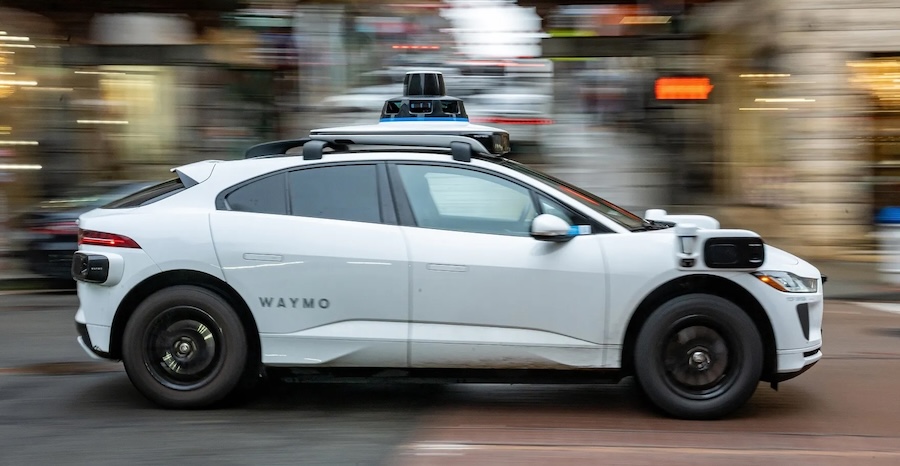
There are currently zero Level 4 autonomous vehicle deployments operating anywhere on the African continent. When we talk about autonomous vehicles (AVs) globally, the discourse centers on Tesla navigating Silicon Valley highways or Waymo cruising through Phoenix. But what happens when you bring an autonomous vehicle to Lagos, Nairobi, or Cairo?
To achieve Level 3 (conditional automation), Level 4 (high automation), or Level 5 (full automation) driving in Africa, the challenge isn't just better AI models or more expensive LiDAR sensors. It is fundamentally a data infrastructure challenge.
For AVs to work on the continent, they must operate in a dual capacity: as intensive consumers of highly precise navigation data, and as massive collectors of localized geospatial data. Here is a realistic look at the data engineering, mapping, and crowdsourcing hurdles we must solve to make autonomous driving a reality in Africa.
Part 1: The AV as a Data Consumer (The Navigation Data Problem)
To safely navigate without human intervention, an AV relies on a stack of navigation data that goes far beyond what Google Maps or Apple Maps currently provides. Achieving Level 3 to Level 5 autonomy requires three layers of localization data, each presenting unique challenges in the African context.
1. High-Definition (HD) Maps vs. Dynamic Reality
Level 4 and 5 AVs do not just "see" the road in real-time; they compare what they see against a pre-compiled, centimeter-accurate HD map. These maps contain 3D lane geometries, curb heights, traffic light positions, and even the exact slope of the road.
The African Reality: In many African cities, road infrastructure is highly dynamic or structurally inconsistent. Lane markings are mostly absent, faded, or obscured by dust. Potholes can alter a road's geometry overnight, and unexpected construction or informal detours are common.
The Data Work Needed: We cannot rely on static HD maps. African AV systems will require vectorized, self-healing HD maps that update in near-real-time. If an AV detects a new road obstruction or a missing lane marking, that telemetry must be instantly processed to update the base map for all other vehicles in the network.
2. Semantic and Contextual Data
AVs need to understand the meaning of their environment. In Western contexts, this means recognizing standard regulatory signs and jaywalkers.
The African Reality: Navigation data in Africa must account for highly complex, informal traffic ecosystems. This includes informal transit systems — danfos in Lagos, matatus in Nairobi, tuk-tuks across East Africa — alongside street vendors weaving through traffic and livestock on peri-urban roads. Traffic enforcement is often manual, relying on hand signals from traffic wardens rather than digital lights.
The Data Work Needed: Computer vision models must be trained on localized datasets, and labeling data must explicitly include African transit archetypes — vehicle classes, informal signaling conventions, and pedestrian behavior patterns that don't exist in Western training corpora. Localization algorithms must also integrate behavioral data stacks that predict the erratic movements of informal minibuses or pedestrians using roads that lack sidewalks.
This is precisely the gap DataLens Africa exists to close. Global AV and computer vision teams building for African roads don't just need more data — they need annotation pipelines built by people who can correctly label a danfo weaving through Third Mainland Bridge traffic or a hand signal from a Lagos traffic warden. That's a data sourcing and annotation problem before it's a modeling problem, and it's structurally underserved by data vendors built for US and European road taxonomies.
3. GNSS and RTK Infrastructure
To know exactly where it is within a lane, an AV uses Global Navigation Satellite Systems (GNSS) paired with Real-Time Kinematic (RTK) positioning to achieve centimeter-level accuracy.
The African Reality: RTK requires a dense network of ground-based reference stations (Continuously Operating Reference Stations, or CORS). While countries like South Africa, Kenya, and Nigeria have made strides, CORS coverage across the continent remains fragmented, leading to GPS drift in deep urban canyons or rural stretches.
The Data Work Needed: Expanding public-private partnerships to build out CORS networks is vital. Concurrently, AV software built for Africa must rely more heavily on odometry and SLAM (Simultaneous Localization and Mapping) to navigate safely when satellite correction signals drop.
Part 2: The AV as a Data Collector (The Crowdsourcing Opportunity)
While the data requirements are steep, the arrival of AVs — and even semi-autonomous Level 2+ vehicles currently entering the African market — presents an unprecedented opportunity. AVs are essentially rolling data centers, equipped with cameras, radar, LiDAR, and ultrasonic sensors. They can become the ultimate tool for mapping Africa.
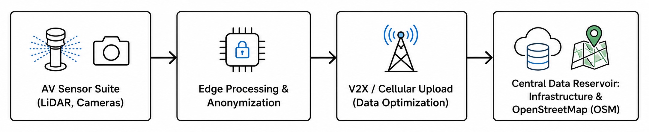
The pipeline, end to end:
- Sensor capture: the AV's onboard suite (LiDAR, cameras, radar, ultrasonic) records the environment continuously.
- Edge processing & anonymization: footage is processed on-vehicle, stripping personally identifiable information and compressing raw sensor logs before anything leaves the car.
- Prioritized upload: critical data (a new pothole, a flooded road, a downed sign) is pushed over cellular/V2X networks first; routine telemetry is queued or transmitted opportunistically to manage bandwidth costs.
- Central data reservoir: aggregated, anonymized data feeds into infrastructure databases and open mapping platforms like OpenStreetMap (OSM).
Automated Infrastructure Auditing
Instead of governments spending millions on manual road surveys, a fleet of sensor-equipped vehicles can continuously audit the environment.
- Pothole and asset mapping: As vehicles drive, computer vision models can automatically tag potholes, broken streetlights, and damaged barriers, streaming this geospatial data directly to municipal databases for rapid response.
- Dynamic traffic flow analytics: By aggregating anonymized speed and routing data, AV fleets can provide hyper-local traffic insights, helping urban planners redesign chaotic intersections.
Democratizing Spatial Data via OpenStreetMap
Africa has a vibrant tech community dedicated to open-source mapping (YouthMappers and local OSM chapters among them). AV data can turbocharge these efforts. By stripping proprietary telemetry and releasing anonymized aerial and street-level imagery trends, AV companies can help open-source contributors map unaddressed informal settlements, rural tracks, and newly built suburbs that commercial map providers overlook.
Part 3: The Data Engineering Pipeline Required for Africa
To transition from theoretical Level 3 to realistic Level 5 autonomy in Africa, data engineers and geospatial experts must collaborate on building a resilient data pipeline designed for local constraints.
Edge AI and Data Optimization: Internet bandwidth is costly and coverage can be spotty along inter-state highways. African AVs cannot rely on uploading raw sensor logs to the cloud. Massive data compression, edge computing (processing data locally on the vehicle), and prioritizing critical data packets over cellular networks (4G/5G) are non-negotiable — this is the same prioritized-upload logic described in the pipeline above, applied continuously rather than just at moments of anomaly detection.
Federated Learning for Privacy and Localization: To respect local data privacy laws like Nigeria's NDPR or South Africa's POPIA, AV infrastructure should lean into federated learning. Vehicles can learn from local road anomalies and share model updates with a central server without exporting raw video footage of citizens.
Hyper-local Weather Data Integration: African rainy seasons bring torrential downpours and flash floods that completely alter road drivability and blind optical sensors. The navigation data stack must ingest real-time, hyper-local meteorological data to proactively adjust routing or hand control back to the driver (Level 3) before the vehicle enters a flooded zone.
"The road to autonomy is paved with data — and specifically, with the kind of locally-grounded, expertly-annotated data that global models can't get anywhere else."
Conclusion: Driving the Future of African Spatial Data
Achieving Level 4 and 5 autonomous driving in Africa is not an impossibility, but it requires us to stop treating AVs as a plug-and-play Western technology. The path forward requires building robust geospatial infrastructure: training AI on the full complexity of African traffic, deploying dense RTK networks, and viewing the autonomous vehicle not just as a luxury mode of transport, but as a critical infrastructure tool that will map, audit, and understand our continent better than ever before.
The road to autonomy is paved with data — and specifically, with the kind of locally-grounded, expertly-annotated data that global models can't get anywhere else. This is the gap DataLens Africa was built to fill.
Building AV, ADAS, or geospatial AI systems for African roads?
DataLens Africa runs the annotation pipelines, localized labeling, and human-in-the-loop review that make training data actually reflect African traffic reality — from danfos and matatus to hand-signaled intersections. Talk to our team or continue to follow our blog for more on where African data infrastructure is headed.